
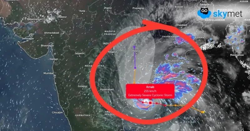
Severe Cyclone Arnab started coming ashore in Andhra Pradesh early on Wednesday, bringing high winds and heavy rain, with a storm surge of up to 2.5 metres expected over low-lying coastal areas.
Severe Cyclone Arnab began making landfall in India's Andhra Pradesh state in the early hours of Wednesday, bringing high-speed winds and heavy rain that uprooted trees and disrupted power supply in places, Reuters reported, citing authorities.
The India Meteorological Department forecast wind speeds of 125 to 135 kilometres per hour over the landfall area, gusting to 150 kilometres per hour, over the next four hours before easing gradually. A storm surge of 1.5 to 2.5 metres above the normal tide was very likely to inundate low-lying areas of Andhra Pradesh over the next six hours. Thousands of people had been evacuated along India's eastern coast during the week and some train and flight services were cancelled ahead of the storm's arrival.
Arnab had spent days moving across the Bay of Bengal toward the Andhra coast, with its outer band reaching the shore and the expected landfall window narrowing to the early hours of October 28. The Bay of Bengal has produced some of India's deadliest storms, and Reuters recalled the super cyclone that killed nearly 10,000 people when it struck Odisha in October 1999.
The landfall timing, wind speeds and surge figures in this story come from the India Meteorological Department as reported by Reuters, and the chief minister's office said no loss of life had been reported so far, although trees were uprooted and power was disrupted in several places. An earlier forecast had put sustained winds somewhat lower, so the figures here are the department's landfall-period forecast rather than a measured peak, and the damage picture is still limited to the first hours ashore.
The immediate risk is to low-lying coastal communities facing the surge and to power and transport links already disrupted by wind and rain. The next confirmed picture will come from the meteorological department's updates as landfall progresses and from daylight damage assessments by state authorities.